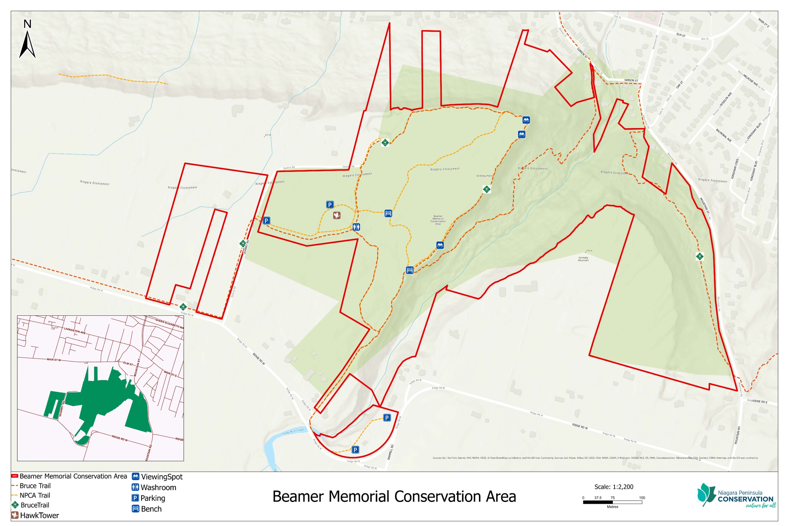
Located in the Town of Grimsby, Beamer Memorial was acquired by NPCA in the late 1960s for escarpment protection and nature study.
Beamer Memorial is 63 hectares in size and offers breathtaking, panoramic views of the Niagara Escarpment and Lake Ontario.
The conservation area is popular for observing the annual spring hawk migration as they pass over the Niagara Peninsula watershed.
The development of the updated management plan for Beamer Memorial Conservation Area is guided by NPCA’s Conservation Areas Strategy, with a strong focus on collaboration and community engagement.
Throughout the planning process, we are committed to working closely with community partners and members to ensure that the vision and objectives of the plan reflect the current priorities, environmental pressures, protection of unique natural heritage, and needs of the community.
This approach will shape the plan’s direction and ensure that decisions made are informed by diverse perspectives.
Due to the sensitive environment of the escarpment, the updated management plan will include natural heritage enhancements, biodiversity protection, and will guide capital investments to improve visitor experience and long-term sustainability of the conservation area.

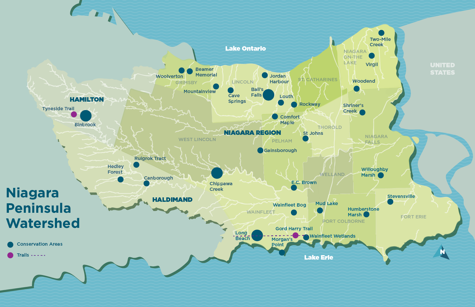
The Niagara Peninsula Conservation Authority (NPCA) is a community-based natural resource management agency that protects, enhances, and sustains healthy watersheds. With 65 years of experience, the NPCA offers watershed programs and services that focus on flood and hazard management, source water protection, species protection, ecosystem restoration, community stewardship, and land management. The NPCA is one of 36 Conservation Authorities in the Province of Ontario and manages 43 Conservation Areas within the Niagara Peninsula watershed held in public trust for recreation, heritage preservation, conservation, and education. The map below highlights the location of many conservation areas that are open to the public.
A watershed is the land that drains into a particular watercourse such as a stream, river, lake. Gravity and the land’s topography (the high and low areas) move water, rain, and snowmelt across the landscape from one area to another.
The Niagara Peninsula Conservation Authority’s watershed area encompasses 2,424 km2, including the entire regional municipality of Niagara, portions of the City of Hamilton (21%), and Haldimand County (25%). Since time immemorial, this area has been the home to Indigenous peoples – a place for sharing, trading, hunting, gathering, stewardship, and friendship. Currently, the watershed supports a population of approximately 520,000 people.
The Niagara Peninsula watershed is a natural treasure of distinct cultural, geological, hydrological, and biological aspects not found elsewhere in North America. It is part of the Carolinian life zone – the most biodiverse and threatened ecoregion in Canada. The Niagara Peninsula watershed boasts approximately 30% natural cover that provides critical habitat such as forested woodlots, slough forests, alvars, and coastal wetlands that support rich biodiversity, including rare plants and animals.
The watershed is uniquely situated between two Great Lakes, with the Niagara River as a boundary shared with the United States of America. As a result, the watershed area includes several notable natural features such as the Niagara Escarpment Biosphere Reserve, the Niagara Falls, Wainfleet Bog, Ball’s Falls, Willoughby Marsh, and other significant landforms such as the Fonthill Kame ice contact-delta complex. The unique microclimate created by the Niagara Escarpment and rich soils supports one of Ontario’s most productive agriculture systems, including vineyards, tender fruit orchards, livestock, and various specialty crops (greenhouses for flowers, vegetables, sod farms, and mushroom farms).
These important watershed features provide life-sustaining benefits for all and many opportunities to discover nature and culture.
Map of Beamer Memorial Conservation Area